Showing posts with label hot pools. Show all posts

Wednesday, January 15, 2020

Walks Around and About some South Island Lakes

Lake Tekapo


There is something very relaxing about walking around lakes.  Or looking down on lakes from nearby hills.  We did both on our travels; some were just short wanders, others were longer hikes.  One of the most stunning was Lake Tekapo, especially as when we were there it was edged by deep drifts of pink and purple lupins.  Some consider lupins a weed on a par with broom and briar but, judging by the number of people taking photographs at the roadsides, others found them as stunning as we did.  A local woman, Connie Scott, planted £100 worth of seeds along the roadsides in 1949—just wanting to make the area more beautiful.  She is buried in Burkes Pass cemetery, remembered on her tombstone as the 'lupin lady'.
            The NZMCA Park where we stayed was hidden away in a clearing amongst pine trees on the shore of Lake Tekapo.  We took a walking track from there around the lakeside into Lake Tekapo township, passing the famous church of the Good Shepherd.  Built in 1935, this church has become one of the most photographed buildings in New Zealand because of its pleasing structure—and the amazing backdrop of turquoise waters and dramatic mountains.  The church was built in recognition of the pioneers of the Mackenzie Country.  Nearby is a bronze statue of a  collie dog, memorial to the working dogs that assisted the pioneering leaseholders and farmers.
Walking around the lake to the summit of Mt John

The Observatory

            We continued beside the lake, then up to the summit of Mount John.  This is home to the Mount John Observatory, one of best places in the world to observe the night sky.  The Observatory houses New Zealand's largest telescope and there are tours for those who want to view the evening or night skies.  In the daytime there are breath taking views of Lake Tekapo, Lake Alexandrina and Lake McGregor.  We wandered from the township along the lakeshore until we found the track that lead uphill (after a couple of false starts).  The track contoured around the hillside before going steeply uphill.  The top of the hill was a good place to stop—and admire the view down to the turquoise-blue, glacier-fed waters of Lake Tekapo and the snow-capped mountains beyond—because there was another steep, up-hill section before reaching the summit.  From here the views were even better.  We could see down to the Lake Tekapo township and across to the far shores of the lake where Tangaroa was parked.  The town looked like a desert oasis with the brown Mackenzie country stretching away in the distance.  In the other direction we could see the nearby Lake Alexandrina and Lake McGregor while, from this height, Lake Tekapo itself now reflected the snowy mountains in its still waters. 
            After admiring the stupendous views, we had a coffee at the aptly-named Astro Cafe, then took another track down, through exotic forest, to the lakeside.  Here we soaked our aching legs in the hottest of the Tekapo Springs' hot pools.  A nice feature was that each of the pools was shaped like one of the district's lakes.  Since we had been walking for over three hours we felt like we deserved a soak.  We don't need much of an excuse to luxuriate in a hot pool—and these were in such a lovely position beside Lake Tekapo.
Hot Pools with great views

            It is less than an hour's drive from Lake Tekapo to Lake Opuha, north of Fairlie.  This man-made lake is tucked away in the Fairlie Basin and there are several places where freedom camping is allowed.  We found a pleasant site, looking across the waters of the lake to the distant mountains.  The lake was constructed as an irrigation reservoir and there is also an electricity generating plant at the outlet of the dam.  We walked around the side of the lake to the dam one afternoon.  It was a peaceful stroll.  Although the lake is popular with those who enjoy water sports, it was early summer and few people were about.
            Next stop was the lakeside at Lake Pukaki where there is a large area for freedom camping.  This lake is the largest in the area, and has Aoraki/Mount Cook towering above the other mountains of the Southern Alps ranged beyond its headwaters.  Like the other lakes in the region, Lake Tekapo has a milky, turquoise-blue colour due to fine rock particles ground up by the glaciers and suspended in the water.  There is a track beside the lake that is part of the Alps to Ocean Cycle Trail, though we just meandered a few kilometres and back again on our bikes.  It was almost Christmas so we pulled out a little wildling pine to make Tangaroa a little more festive.
            A side trip to Aoraki/Mount Cook was a must.  This World Heritage Site covers more than 70,000 hectares and includes New Zealand's tallest mountain and largest glacier.  There are several walks here ranging between ten minutes and an hour.  Where else in the country can you go for a stroll and see icebergs? 
            From Tangaroa's lakeside spot we walked the Pukaki Kettle Hole Track, which started just across the road.  This short walk took us high up the hillside overlooking Lake Pukaki and in amongst moraine hummocks.  The kettle hole itself was formed by melting glacial ice long ago.  From the hill beside the Kettle Hole Lake we had 360 degree views and those looking towards Mount Cook were amazing, even though the day was rather dull.  Sometimes clouds make dramatic scenery all the more atmospheric.

            We couldn't fault the weather when we went to Glenorchy though—the sky was blue and not a cloud to be seen.  As we drove beside Lake Wakatipu from Queenstown, there was a different and jaw-dropping view around each bend in the road.  Serious trampers base themselves at Glenorchy or Kinloch to walk multi-day tramps, but we were happy to do two shorter walks.  We started in Glenorchy itself where the Lagoon Walkway looped through wetlands beside the lake.  The track began near the wharf, meandering beside Lagoon Creek amidst willows, flowers and flax.  The views of Mt Earnslaw soon become reflected in areas of water as the track lead onto boardwalks.  The first part of the Lagoon Walkway was built in 1997 but was doubled in size with an extension in 2012.  Walkers can do the original loop, the longer circuit or a figure of eight.
On the boardwalk

            The boardwalk passed between mirror-like pools, and in some places there were side tracks, with seats for contemplation of the snow-capped peaks.  Bird life was prolific with plenty of black swans, paradise ducks and Canada geese.  The final part of the walk followed the flood bank back to town.  The walk had only taken about an hour, so we decided to tackle the Invincible Mine Track which was just north of Glenorchy, in the Rees Valley.
            Shepherds working for William Rees in 1861 were the first Europeans to arrive at the head of Lake Wakatipu.  Shortly after this, gold miners began to appear when gold was found at the nearby Richardson Range.  Although there is little trace now of the thriving settlements that once called the Rees Valley home, there were some remnants of the mine to left for us to discover.
            The track began on the terraces of the Rees River and took us up through beech forest, following the route the miners made in 1880.  After about half an hour's walking we came across the remains of a cookhouse hut, with rusty billies scattered around.  It was hard to believe that they had been there for a hundred years or more!  The higher the track went, the more sensational the views became.  In one direction we could look back towards Glenorchy and Kinloch, the other way had panoramas into Mt Aspiring National Park. 

Lunch spot

            The mine site itself was reached after a further half hour.  We were fascinated by the relics and spent quite a while exploring.  First we examined the remains of a water wheel and, a little further on, the entrance to the mine.  There was also a unique set of seven berdans, which are the large cast iron bowls used for grinding ore. We ate our lunch gazing down the Rees Valley towards Mt Earnslaw with only hawks for company.  It was one of those sights, and experiences, which are truly unforgettable.
            Before heading back to the bus we went to Paradise.  How could we not?  There is not much there except for the sign and some horse paddocks.  I had imagined that the early settlers were very happy with their environment, but the DOC ranger at the start of the Rees Dart track disillusioned me—Paradise is named after the ducks that inhabit the valley.
            The next mountain we climbed was the Rocky Mountain, in the Diamond Lake Conservation Area, close to Lake Wanaka.  It was a hot day and there was a 400-metre climb to the summit.  I spent the way up veering between thinking, 'wow, these views are amazing!' and 'why did I think this was a good idea!'  Reaching the summit underlined the wow factor though—and despite the struggle it definitely was a good idea.
At the start of the track

View on the way up

            There are several walks in the Diamond lake Conservation Area.  The first is a 45- minute circuit of the lake; the second is a one-hour return to the Diamond Lake lookout; continuing further is the Lake Wanaka Lookout, two hours return; and finally the Rocky Mountain Summit (which we walked) a three-hour, seven-kilometre loop.
            Since it was a clear, sunny day we opted for the Rocky Mountain track which lead from the car park past Diamond Lake, fringed with willow and raupō.  Amazingly, winters were so severe in the 1950s that the lake as often used for ice skating.  The track to the lake lookout went steeply uphill, on wooden steps under rocky schist cliffs.  We took the opportunity to rest at the lookout and pondered why Diamond Lake was so called.  It is more of a teardrop shape but glitters in the sunlight, so maybe that suggested the name.
            Onward and upward again, then the track split.  We took the eastern branch, and then wandered along a side track to the Lake Wanaka lookout.  There were fantastic views from here, looking across Lake Wanaka and its islands to The Peninsula and the peaks beyond.  The track zigzagged steeply in places, and then rounded more and more bluffs, until finally the summit, with its cairn, came into view.  The summit is 775 metres above sea level and there were 360 degree views from this spot.  We had been blown away by the views of Lake Wanaka on the climb up but the view west from the summit, towards the snowy-capped mountains of Mt Aspiring National Park, was equally breathtaking. 
View at the summit

On the way down

            Eventually we continued along the track, down the western loop.  There were steep cliffs beside the track, which hair-pinned down, then passed through some bush-filled gullies.  At times the track was a scramble around rocky cliffs and these sections are apparently very dangerous in winter.  Rock climbers love the cliffs though and have established routes—some fitting names they have chosen are Rock Hudson and Sharon Stone.
            Before moving on from this part of the South Island we drove towards the west coast, freedom camping on the shores of Lake Hawea.  We were planning to stay at a DOC campground further along beside the lake, but the condition of the road made us decide against it.  We weren't sure if freedom camping was allowed here as the signs were ambiguous—but we stayed the night anyway.  From the hillside behind the bus we enjoyed the view—looking down at our tiny white home, dwarfed on all sides by lofty mountains.                  Later we walked along the road beside the lake for quite a while—we kept wondering what the view would be like around the next bend.  Eventually we turned back but before we got far had to quickly scramble up the hill.  A farmer was driving a herd of skittish cattle ahead of his quad bike, ably assisted by three panting dogs.  Then, as darkness fell, we found ourselves alone under the starry sky with the lake an inky and mysterious black.
Tangaroa at the lakeside, Lake Hawea

Information about places mentioned in this post - correct at the time of writing
Walks
  • ·         Tekapo Mount John Walkway

www.doc.govt.nz/parks-and-recreation/places-to-go/canterbury/places/lake-tekapo-area/things-to-do/lake-tekapo-town-tracks
Tramping track, 3 hr loop
Access: from lakeside near Tekapo Springs

  • ·         Lake Opuha walk

mackenzienz.com/tours/walking-tracks-fairlie
1 hr return, easy
Access: Trentham Rd, Lake Opuha

  • ·         Glenorchy Lagoon Walkway

www.doc.govt.nz/parks-and-recreation/places-to-go/otago/places/glenorchy-area/things-to-do/glenorchy-walkway
1-2 hr loop walk, easy
Access: Mull St, Glenorchy

  • ·         Invincible Mine Track

www.doc.govt.nz/parks-and-recreation/places-to-go/otago/places/glenorchy-area/things-to-do/invincible-gold-mine-track
3 hr return, easy: walking track
Access: Rees Valley Rd, 30 min drive from Glenorchy

  • ·         Rocky Mountain Summit Track

www.doc.govt.nz/parks-and-recreation/places-to-go/otago/places/diamond-lake-and-hospital-flat/things-to-do/diamond-lake-and-rocky-mountain-walks
7 km, 3 hr return, easy: walking track (but a steep, uphill climb)
Access: Wanaka-Mount Aspiring Rd, 18.5 km from Wanaka

Places to visit
  • ·         Tekapo Hot Springs

6, Lakeside Dr, Lake Tekapo
www.tekaposprings.co.nz
Hours: 10.00 am-9.00 pm daily
Entry price: adult $27, senior $22, child $15

  • ·         Aoraki/Mount Cook national Park Visitor Centre

1, Larch Grove, Aoraki/Mount Cook
www.doc.govt.nz/parks-and-recreation/places-to-go/canterbury/places/aoraki-mount-cook-national-park
several easy walks from 10 min  to 2 hours return


Tuesday, January 14, 2020

Glacier Country - Greymouth to Jacksons Bay

Fishing boats at Greymouth


Even on a wet and wild day there is something wonderful about being parked beside the beach, watching the waves crashing and the seagulls joy-riding on the gusts.  Later there is the prospect of beach-combing as the sun breaks through.  On sunny days the sun sparkles on the waves as they gently paw at the sand.  That's why we kept returning to Greymouth, freedom camping along the Esplanade at Cobden.  Māori named the area Mawhera which means wide river mouth—a nicer sounding name than Greymouth, though the river is named after Sir George Grey and it doesn't refer to the colour of the water. 
            There is plenty to see in the town, with jade carvers to visit and tempting cafes to eat in.  We walked along the Floodwall from Cobden Bridge, and later, along the beach to the Point Elizabeth walkway, just two of the many walks in the area.  The Floodwall walk took about half an hour but can be extended to several hours by continuing around the lagoon.  There are reminders of Greymouth's mining history along the walk, as well as information panels.  Part of the original s-shaped Cobden Bridge, which was built to span the Grey River in 1896, is now a feature at the end of the Floodwall, beside the current bridge. 
            The Point Elizabeth walk takes up to three hours return, depending on your starting point, and passes through coastal forest to the lookout.  Māori legend explains that the hills viewed looking south from here represent a giant tuatara drinking from the river.  On a clear day there are views past Hokitika to Aoraki/Mt Cook.  Looking north, the coast stretched past Punakaiki towards Karamea.  There were no other walkers on the track when we were there and it was difficult to believe that after the discovery of gold in 1865 one thousand men worked the terrace between Elizabeth Point and the Grey River.  Now it is home to little blue penguins and fur seals.
            While we were in the area we cycled the West Coast Wilderness Trail.  This ran from Greymouth to Ross, going inland at Kumara to Lake Kaniere and 'Cowboy Paradise' before reaching the coast again at Hokitika.  From here the trail went down the coast to Mananui, then through wetlands and native forest following the historic Mahinapua tramline, before looping by road to an old rail corridor that finished in Ross.
On the West Coast Cycle Trail at Kumara

Another section of the cycle trail

            We both cycled the section from Greymouth to Kumara.  Leaving Greymouth town and port, the track wended its way beside the coast for 30 kilometres, amongst dunes and tidal lagoons, to the Taramakau Bridge near Kumara.  This town was almost the last in the area to experience a gold-rush.  Nothing had been found until two miners setting up an illicit whiskey still found nuggets in the gravel.  Before long Kumara had fifty pubs and there were banks, churches, a police station and courthouse, shops, a newspaper and two theatres.  Richard Seddon, MP for 28 years, and Premier for 13 of them, lived on Kumara for two decades, from the beginning of the gold-rush.  Today Kumara is very quiet but the cycle trail has bought new life and prosperity to the township.  Buildings have been spruced up and many provide food and accommodation for the cyclists passing through.
            Malcolm rode a more challenging section from Lake Kaniere, which really does go through a wild west town—Cowboy Paradise (where you can be a cowboy for a day).  I took the car and did a less physically challenging route, driving beside Lake Kaniere to the Hokitika Gorge.  Lake Kaniere is eight kilometres in length and two kilometres wide.  Popular for water sports, fishing and family picnics in mid-summer,  the lakeside was deserted when I drove past and I didn't meet any other vehicles as I drove along the narrow, bush-lined, gravel road past Dorothy Falls, finally emerging into lush farmland near the Hokitika Gorge. 
The Hokitika Gorge

            One of the 'must-do's' in the area, the Hokitika Gorge walk took about ten minutes from the small car park.  The viewpoint looked down on the granite gorge and it's amazing turquoise waters.  A path lead down to a swingbridge over the gorge—a very photogenic destination.
            We moved Tangaroa to the NZMCA park at Hokitika before cycling the final stage of the trail.  Hokitika is enjoying an up-surge in popularity, partly due to the success of Eleanor Catton's novel The Luminaries.  I had a personal interest in Hokitika during its early days; the brother of my great-great-grandmother came to seek his fortune in the area back in the mid 1860s.  A search of the cliff-top cemetery revealed his gravestone and, in another part of the cemetery, the resting places of his family.  Because he was not a Catholic he rests alone—far from his Anglican relatives back in England and separate from his wife, children and grandchildren.


            Hokitika township was full of galleries and shops.  Here you could buy greenstone, gold and silver, glass, pottery and photographs produced by local craftspeople.  The town is set right on the beach which is a wild, driftwood-strewn, West Coast one.  In January each year the locals construct sculptures from the flotsam and jetsam, which remain until reclaimed by the wind and tides. 
            The West Coast weather lived up to its reputation here and we experienced several days of torrential rain.  Our solar panels couldn't produce any power and, for the first time, our battery was low.  The temperature had plummeted though it was mid-summer, and we had to find a hostelry for a long lunch in a warm, dry place.  When we emerged a few hours later the sun was shining and the clouds had blown away.
            We cycled the final leg of the West Coast Wilderness Trail the next day, taking the car down to Ross and riding back to Hokitika.  The first section began near the Totara Bridge, built in 1908, and followed an old rail corridor beside the coast and Totara Lagoon.  After a short road section we rode down the route of a bush tramline, through some pretty bush, to a boardwalk at Lake Mahinapua.  Because there had been so much rain the boardwalk was nearly submerged.  From here it was an easy ride back to the bus.
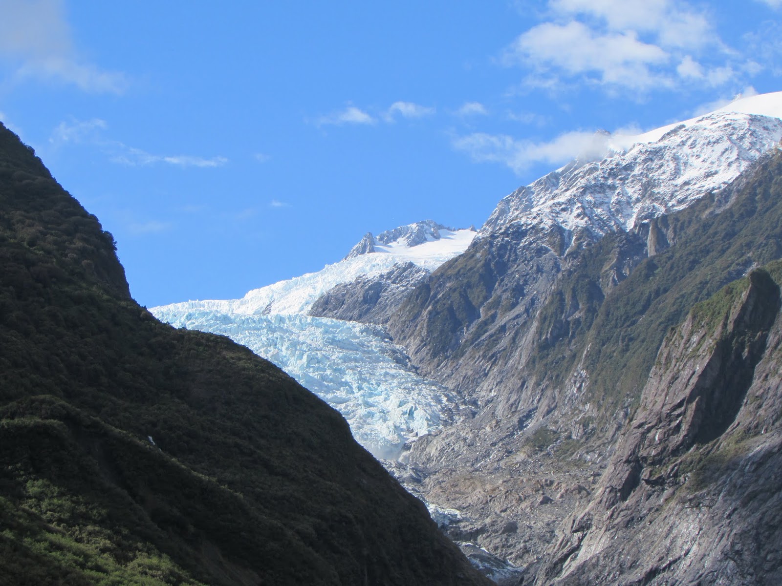
            Next we encountered glacier country, visiting Franz Josef and Fox Glaciers.  Franz Josef Glacier was named after the Austrian Emperor by the explorer Julius von Haast.  The Māori name is Kā Roimata o Hine Hukatere, the tears of Hine Hukatere.  Legend relates how Hine Hukatere, who loved mountaineering, encouraged her lover to venture into with her into the Alps.  Her lover perished in an avalanche and the glacier was formed from Hine Hukatere's tears.  The glacier is currently 12 kilometres in length, terminating nineteen kilometres from the Tasman Sea and fed by a large, high-altitude snowfield.  In the last ice age the glacier extended beyond the coastline.  Since its first sighting by Europeans in 1859 the glacier has exhibited a cycle of advance and retreat, with global climate change causing the glacier to retreat rapidly over the last decade.
            Because the weather was changeable, we set off early one fine morning to view the glacier, hoping to see it before any rain arrived.  Along with many other tourists we parked in the car park and trekked up to the glacier along the Valley Walk.  This was a moonscape route over shingle and the rock from the riverbed; it took about 45 minutes to get to the foot of the glacier.  The walk was quite rough going, but the snowy-white glacier and surrounding peaks were so eye-catching that it was totally worthwhile. 
Franz Josef Glacier

Peters Pool

Glacier Hot Pools

            When we got back to the car park the weather was still fine so we took the short, steep track to the top of Sentinel Rock.  There were great views of the whole glacier valley from here, though it was strange to think that in 1865 the glacier had just retreated from the rock—and just prior to that it had been completely covered by ice.  We finished our Franz Josef experience by taking the Douglas Walk loop track which passed Peters Pool, a small kettle-lake formed by melting ice, which reflected the snowy mountains of the glacial valley.
            In the afternoon we decided to take a soak in the Glacier Hot Pools in the Franz Josef township —to reward ourselves for our four hours of tramping.  The sky was still blue so we walked from the nearby NZMCA Park, where we were staying.  These pools are prettily landscaped in a bush setting.  We hadn't been soaking long however when large hailstones began to pound down, bouncing off the wooden decking.  It was an unusual and rather surreal experience—in mid-summer too!
            It was only a half-hour drive from Franz Josef to Fox Glacier township.  We freedom camped beside the Cook River and were rewarded by views of the glacier and the snowy alps around it.  The following day we walked up to look at the glacier, which was a similar experience to our Franz Josef one.  There were diggers loading trucks with rock from the river and it was only seeing them—and tourists on the glacier glimpsed through a telephoto lens—that really brought home the scale of the landscape.
Freedom camping near Fox Glacier

Humans dwarfed by the glacier

            Later we took the car from our freedom spot to Gillespies Beach.  The drive was through some magnificent rimu forest, said to be amongst the best in the Westland Tai Poutini National Park.  Beside this deserted beach there was once a thriving gold town—after the eponymous Gillespie found gold there in 1865—though its heyday was short-lived.  The remains of a bucket dredge and a suction dredge, half smothered by bush, could be seen from a walkway.
old gold dredges

            From Fox Glacier, the Haast Highway passed through typical West Coast scenery.  Tall forests stretched either side of the road, half-hidden lakes were glimpsed, and waterfalls poured down mountainsides.  It was often raining but that just made the waterfalls more spectacular and the walks that we managed more atmospheric.  We experienced 50 millimetres of rain overnight while parked beside Lake Moeraki, then paddled through puddles along the nearby Monro Track the next day.  We had hoped to see Fiordland Crested Penguins at Monro Beach, but discovered that we were there at the wrong time of year.
            Confusingly there were three settlements called Haast; Haast Junction on the state highway; Haast Village, just off the road and Haast Beach on the Jackson Bay road, but they were all within a few kilometres of each other.  The weather was fine so we planned to explore the road to Jackson Bay.  First stop was the DOC Visitor Centre at Haast Junction.  This building was a destination in its own right— it was surrounded by landscaped wetlands and there were viewing rooms inside.  There was also a museum area outlining early Māori and settler history.  Information gathered, we set off along the road to Jackson Bay.

On the road to Jackson Bay

            The Jackson Bay road felt remote, but all 48 kilometres were sealed which made for a smooth trip.  At Okuru river mouth there were several cribs —baches to us North Islanders—and white-baiting stands.  Out to sea were views of the Open Bay Islands, named by Captain Cook in 1770, and also known as the Castaway Islands.  Ten sealers were dropped off at the islands in 1810, but their ship never returned and it was three years later when they were rescued.  They had collected 11,000 skins during that time, helping to make the fur seals an endangered species.  Now the islands are a wildlife sanctuary for seals, crested penguins and other native creatures (including rare land leeches).
            Just down the road was Hapuka Estuary, where there was a peaceful, 20-minute loop walk through board-walked lagoons and towering rainforest.  This wetland area is also a sanctuary —for whitebait—allowing their stocks to be maintained, despite the coaster's love of the delicacy.  It is reported to be stunning in spring when the kowhai is in flower and the canopy is full of birds. 

            From Hannahs Clearing the road angled inland through dense forest, which was so close to the roadside that it was like driving through a green tunnel.  One of the most stunning views of Fiordland peaks was from the long, one-lane bridge over the Arawhata River.  Luckily there was not much traffic when we were there!  From here the road turned back and rejoined the coast at Neils Beach.  This was a lovely spot for lunch, with views to Jackson Bay settlement and up the coast to Haast.  We were delighted when we noticed a couple of rare Hectors Dolphins cruising lazily up and down right in front of us.
Wharf at Jackson Bay

            Jackson Bay was a small fishing village with a wonderfully photogenic jetty and a mobile seafood restaurant.  Back in the 1870s it was a planned settlement and had a population of 400, made up of Scandinavians, Germans, Poles, Italians, Irish and English, though after a few years most left the area.  Now it is a lovely, quiet place to eat fish and chips while admiring the wonderful scenery.  A great road trip to end our adventures on the West Coast.
Information about places mentioned in this post - correct at time of writing
Walks

  • ·         Point Elizabeth Walkway

www.doc.govt.nz/parks-and-recreation/places-to-go/west-coast/places/greymouth-area/things-to-do/tracks/point-elizabeth-walkway
5.5 km one way, 1 hr 45 min, easy
Access: North Beach Rd, Greymouth

  • ·         Floodwall Walk, Greymouth

accessed from several points, easy

  • ·         Franz Josef walks:

http://www.doc.govt.nz/parks-and-recreation/places-to-go/west-coast/places/westland-tai-poutini-national-park/things-to-do/tracks/franz-josef-glacier-ka-roimata-o-hine-hukarere-walk/
Sentinel Rock Track:  900 m return, 20 min, easy: walking track
Douglas Loop Track:  3.9 km return, 1 hr, easy: walking track
Access: Glacier Access Rd, Franz Josef

  • ·         Gillespies Beach Walks

www.doc.govt.nz/parks-and-recreation/places-to-go/west-coast/places/gillespies-beach/things-to-do/tracks/gillespies-beach-walking-tracksGillespies Suction Dredge Walk:  400m loop, 15 min, easy: walking track
  • Gillespies Bucket Dredge Walk:  1.6 km, 30 min return, easy: walking track

Access: Gillespies Beach Rd, off Cook Flat Rd, Fox Glacier

  • ·         Monro Beach Track

www.doc.govt.nz/parks-and-recreation/places-to-go/west-coast/places/haast-paringa-and-moeraki-rivers-area/things-to-do/tracks/walks-north-of-haast-township
4.7 km return, 1 hr 30 min, easy: walking track
Access: SH 6, 30 km north of Haast

  • ·         Hapuka Estuary Walk

www.doc.govt.nz/Documents/parks-and-recreation/tracks-and-walks/west-coast/haast-regional-walks.pdf
1 km, 20 min loop walk, easy: walking track
Access: Jackson Bay Rd

Cycle Trails
  • ·         West Coast Wilderness Cycle Trail

Greymouth to Kumara, 32 km, grade 2: easy
Kumara to Cowboy Paradise, 36 km, grade 2: easy
Cowboy Paradise to Hokitika, 36 km, grade 2: easy
Hokitika to Ross, 33 km, grade 2: easy
www.westcoastwildernesstrail.co.nz

Places to visit
  • ·         Franz Josef Glacier

Franz Josef Glacier Access Rd, Franz Josef
www.doc.govt.nz/parks-and-recreation/places-to-go/west-coast/places/westland-tai-poutini-national-park/franz-josef-glacier
Walk to the glacier from the car park 5.4 km return, I hr 30 min, easy: walking track

  • ·         Fox Glacier

Glacier View Rd, Fox Glacier
www.doc.govt.nz/parks-and-recreation/places-to-go/west-coast/places/westland-tai-poutini-national-park/fox-glacier-area
walk to the glacier 1 hr return

The Daytime Kiwi - Milford Sound and Stewart Island

Milford Sound Milford Sound is possibly the South Island's most iconic sights.   We were hoping for a period of good weather so ...