 |
| Fishing boats at Greymouth |
Even on a wet
and wild day there is something wonderful about being parked beside the beach,
watching the waves crashing and the seagulls joy-riding on the gusts. Later there is the prospect of beach-combing
as the sun breaks through. On sunny days
the sun sparkles on the waves as they gently paw at the sand. That's why we kept returning to Greymouth,
freedom camping along the Esplanade at Cobden.
Māori named the area Mawhera which means wide river mouth—a nicer
sounding name than Greymouth, though the river is named after Sir George Grey
and it doesn't refer to the colour of the water.
There
is plenty to see in the town, with jade carvers to visit and tempting cafes to
eat in. We walked along the Floodwall
from Cobden Bridge, and later, along the beach to the Point Elizabeth walkway,
just two of the many walks in the area.
The Floodwall walk took about half an hour but can be extended to
several hours by continuing around the lagoon.
There are reminders of Greymouth's mining history along the walk, as
well as information panels. Part of the
original s-shaped Cobden Bridge, which was built to span the Grey River in
1896, is now a feature at the end of the Floodwall, beside the current
bridge.
The
Point Elizabeth walk takes up to three hours return, depending on your starting
point, and passes through coastal forest to the lookout. Māori legend explains that the hills viewed
looking south from here represent a giant tuatara drinking from the river. On a clear day there are views past Hokitika to
Aoraki/Mt Cook. Looking north, the coast
stretched past Punakaiki towards Karamea.
There were no other walkers on the track when we were there and it was
difficult to believe that after the discovery of gold in 1865 one thousand men
worked the terrace between Elizabeth Point and the Grey River. Now it is home to little blue penguins and
fur seals.
While
we were in the area we cycled the West Coast Wilderness Trail. This ran from Greymouth to Ross, going inland
at Kumara to Lake Kaniere and 'Cowboy Paradise' before reaching the coast again
at Hokitika. From here the trail went
down the coast to Mananui, then through wetlands and native forest following
the historic Mahinapua tramline, before looping by road to an old rail corridor
that finished in Ross.
 |
| On the West Coast Cycle Trail at Kumara |
 |
| Another section of the cycle trail |
We
both cycled the section from Greymouth to Kumara. Leaving Greymouth town and port, the track
wended its way beside the coast for 30 kilometres, amongst dunes and tidal
lagoons, to the Taramakau Bridge near Kumara.
This town was almost the last in the area to experience a
gold-rush. Nothing had been found until
two miners setting up an illicit whiskey still found nuggets in the
gravel. Before long Kumara had fifty
pubs and there were banks, churches, a police station and courthouse, shops, a
newspaper and two theatres. Richard
Seddon, MP for 28 years, and Premier for 13 of them, lived on Kumara for two
decades, from the beginning of the gold-rush.
Today Kumara is very quiet but the cycle trail has bought new life and
prosperity to the township. Buildings
have been spruced up and many provide food and accommodation for the cyclists passing
through.
Malcolm
rode a more challenging section from Lake Kaniere, which really does go through
a wild west town—Cowboy Paradise (where you can be a cowboy for a day). I took the car and did a less physically
challenging route, driving beside Lake Kaniere to the Hokitika Gorge. Lake Kaniere is eight kilometres in length
and two kilometres wide. Popular for
water sports, fishing and family picnics in mid-summer, the lakeside was deserted when I drove past
and I didn't meet any other vehicles as I drove along the narrow, bush-lined,
gravel road past Dorothy Falls, finally emerging into lush farmland near the
Hokitika Gorge.
 |
| The Hokitika Gorge |
One of the 'must-do's' in the area,
the Hokitika Gorge walk took about ten minutes from the small car park. The viewpoint looked down on the granite
gorge and it's amazing turquoise waters.
A path lead down to a swingbridge over the gorge—a very photogenic
destination.
We
moved Tangaroa to the NZMCA park at
Hokitika before cycling the final stage of the trail. Hokitika is enjoying an up-surge in
popularity, partly due to the success of Eleanor Catton's novel The Luminaries. I had a personal interest in Hokitika during
its early days; the brother of my great-great-grandmother came to seek his
fortune in the area back in the mid 1860s.
A search of the cliff-top cemetery revealed his gravestone and, in
another part of the cemetery, the resting places of his family. Because he was not a Catholic he rests
alone—far from his Anglican relatives back in England and separate from his
wife, children and grandchildren.


Hokitika
township was full of galleries and shops.
Here you could buy greenstone, gold and silver, glass, pottery and
photographs produced by local craftspeople.
The town is set right on the beach which is a wild, driftwood-strewn,
West Coast one. In January each year the
locals construct sculptures from the flotsam and jetsam, which remain until
reclaimed by the wind and tides.
The West Coast weather lived up to
its reputation here and we experienced several days of torrential rain. Our solar panels couldn't produce any power
and, for the first time, our battery was low.
The temperature had plummeted though it was mid-summer, and we had to
find a hostelry for a long lunch in a warm, dry place. When we emerged a few hours later the sun was
shining and the clouds had blown away.
We
cycled the final leg of the West Coast Wilderness Trail the next day, taking
the car down to Ross and riding back to Hokitika. The first section began near the Totara
Bridge, built in 1908, and followed an old rail corridor beside the coast and
Totara Lagoon. After a short road
section we rode down the route of a bush tramline, through some pretty bush, to
a boardwalk at Lake Mahinapua. Because
there had been so much rain the boardwalk was nearly submerged. From here it was an easy ride back to the
bus.
Next
we encountered glacier country, visiting Franz Josef and Fox Glaciers. Franz Josef Glacier was named after the
Austrian Emperor by the explorer Julius von Haast. The Māori name is Kā Roimata o Hine Hukatere,
the tears of Hine Hukatere. Legend
relates how Hine Hukatere, who loved mountaineering, encouraged her lover to
venture into with her into the Alps. Her
lover perished in an avalanche and the glacier was formed from Hine Hukatere's
tears. The glacier is currently 12
kilometres in length, terminating nineteen kilometres from the Tasman Sea and
fed by a large, high-altitude snowfield.
In the last ice age the glacier extended beyond the coastline. Since its first sighting by Europeans in 1859
the glacier has exhibited a cycle of advance and retreat, with global climate
change causing the glacier to retreat rapidly over the last decade.
Because
the weather was changeable, we set off early one fine morning to view the
glacier, hoping to see it before any rain arrived. Along with many other tourists we parked in
the car park and trekked up to the glacier along the Valley Walk. This was a moonscape route over shingle and
the rock from the riverbed; it took about 45 minutes to get to the foot of the
glacier. The walk was quite rough going,
but the snowy-white glacier and surrounding peaks were so eye-catching that it
was totally worthwhile.
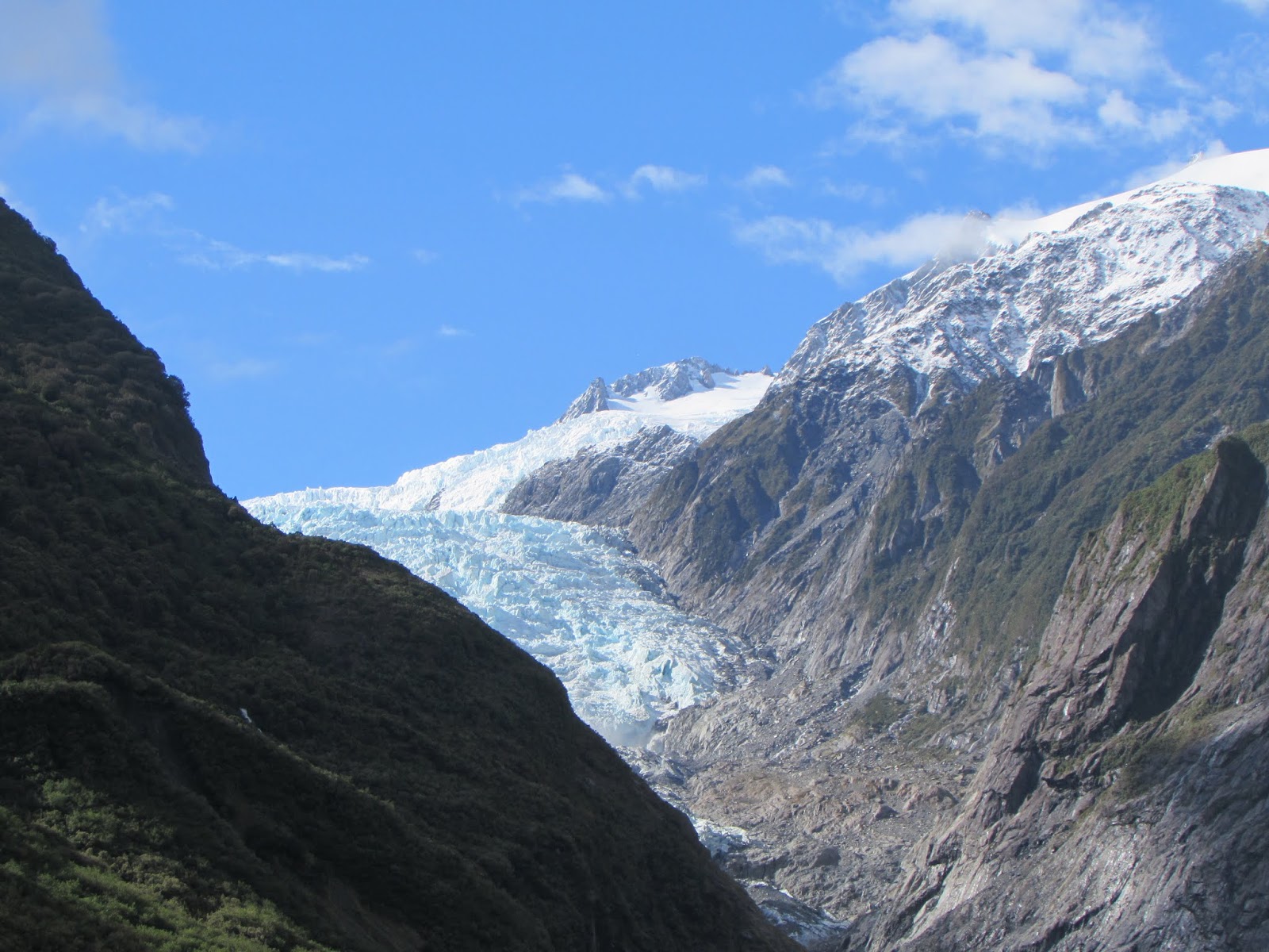 |
| Franz Josef Glacier |
 |
| Peters Pool |
 |
| Glacier Hot Pools |
When
we got back to the car park the weather was still fine so we took the short,
steep track to the top of Sentinel Rock.
There were great views of the whole glacier valley from here, though it was
strange to think that in 1865 the glacier had just retreated from the rock—and
just prior to that it had been completely covered by ice. We finished our Franz Josef experience by
taking the Douglas Walk loop track which passed Peters Pool, a small
kettle-lake formed by melting ice, which reflected the snowy mountains of the
glacial valley.
In
the afternoon we decided to take a soak in the Glacier Hot Pools in the Franz
Josef township —to reward ourselves for our four hours of tramping. The sky was still blue so we walked from the
nearby NZMCA Park, where we were staying.
These pools are prettily landscaped in a bush setting. We hadn't been soaking long however when
large hailstones began to pound down, bouncing off the wooden decking. It was an unusual and rather surreal
experience—in mid-summer too!
It
was only a half-hour drive from Franz Josef to Fox Glacier township. We freedom camped beside the Cook River and
were rewarded by views of the glacier and the snowy alps around it. The following day we walked up to look at the
glacier, which was a similar experience to our Franz Josef one. There were diggers loading trucks with rock
from the river and it was only seeing them—and tourists on the glacier glimpsed
through a telephoto lens—that really brought home the scale of the landscape.
 |
| Freedom camping near Fox Glacier |
 |
| Humans dwarfed by the glacier |
Later
we took the car from our freedom spot to Gillespies Beach. The drive was through some magnificent rimu
forest, said to be amongst the best in the Westland Tai Poutini National Park. Beside this deserted beach there was once a
thriving gold town—after the eponymous Gillespie found gold there in 1865—though
its heyday was short-lived. The remains
of a bucket dredge and a suction dredge, half smothered by bush, could be seen
from a walkway.
 |
| old gold dredges |
From
Fox Glacier, the Haast Highway passed through typical West Coast scenery. Tall forests stretched either side of the
road, half-hidden lakes were glimpsed, and waterfalls poured down
mountainsides. It was often raining but
that just made the waterfalls more spectacular and the walks that we managed
more atmospheric. We experienced 50
millimetres of rain overnight while parked beside Lake Moeraki, then paddled
through puddles along the nearby Monro Track the next day. We had hoped to see Fiordland Crested
Penguins at Monro Beach, but discovered that we were there at the wrong time of
year.
Confusingly
there were three settlements called Haast; Haast Junction on the state highway;
Haast Village, just off the road and Haast Beach on the Jackson Bay road, but
they were all within a few kilometres of each other. The weather was fine so we planned to explore
the road to Jackson Bay. First stop was
the DOC Visitor Centre at Haast Junction.
This building was a destination in its own right— it was surrounded by
landscaped wetlands and there were viewing rooms inside. There was also a museum area outlining early
Māori and settler history. Information
gathered, we set off along the road to Jackson Bay.
 |
| On the road to Jackson Bay |
The
Jackson Bay road felt remote, but all 48 kilometres were sealed which made for
a smooth trip. At Okuru river mouth
there were several cribs —baches to us North Islanders—and white-baiting stands. Out to sea were views of the Open Bay
Islands, named by Captain Cook in 1770, and also known as the Castaway
Islands. Ten sealers were dropped off at
the islands in 1810, but their ship never returned and it was three years later
when they were rescued. They had
collected 11,000 skins during that time, helping to make the fur seals an
endangered species. Now the islands are
a wildlife sanctuary for seals, crested penguins and other native creatures
(including rare land leeches).
Just
down the road was Hapuka Estuary, where there was a peaceful, 20-minute loop
walk through board-walked lagoons and towering rainforest. This wetland area is also a sanctuary —for
whitebait—allowing their stocks to be maintained, despite the coaster's love of
the delicacy. It is reported to be
stunning in spring when the kowhai is in flower and the canopy is full of
birds.

From Hannahs Clearing the road
angled inland through dense forest, which was so close to the roadside that it
was like driving through a green tunnel.
One of the most stunning views of Fiordland peaks was from the long,
one-lane bridge over the Arawhata River.
Luckily there was not much traffic when we were there! From here the road turned back and rejoined the
coast at Neils Beach. This was a lovely
spot for lunch, with views to Jackson Bay settlement and up the coast to
Haast. We were delighted when we noticed
a couple of rare Hectors Dolphins cruising lazily up and down right in front of
us.
 |
| Wharf at Jackson Bay |
Jackson
Bay was a small fishing village with a wonderfully photogenic jetty and a
mobile seafood restaurant. Back in the
1870s it was a planned settlement and had a population of 400, made up of
Scandinavians, Germans, Poles, Italians, Irish and English, though after a few
years most left the area. Now it is a
lovely, quiet place to eat fish and chips while admiring the wonderful
scenery. A great road trip to end our
adventures on the West Coast.
Information about places mentioned in this post - correct at time of writing
Walks
- ·
Point Elizabeth Walkway
www.doc.govt.nz/parks-and-recreation/places-to-go/west-coast/places/greymouth-area/things-to-do/tracks/point-elizabeth-walkway
5.5 km one way, 1 hr 45
min, easy
Access: North Beach Rd,
Greymouth
- ·
Floodwall Walk, Greymouth
accessed from several
points, easy
- ·
Franz Josef walks:
http://www.doc.govt.nz/parks-and-recreation/places-to-go/west-coast/places/westland-tai-poutini-national-park/things-to-do/tracks/franz-josef-glacier-ka-roimata-o-hine-hukarere-walk/
Sentinel Rock
Track:
900 m return, 20 min, easy: walking track
Douglas Loop Track: 3.9 km return, 1 hr, easy:
walking track
Access: Glacier Access
Rd, Franz Josef
- ·
Gillespies Beach Walks
www.doc.govt.nz/parks-and-recreation/places-to-go/west-coast/places/gillespies-beach/things-to-do/tracks/gillespies-beach-walking-tracksGillespies Suction
Dredge Walk:
400m loop, 15 min, easy: walking track
- Gillespies Bucket
Dredge Walk:
1.6 km, 30 min return, easy: walking track
Access: Gillespies Beach
Rd, off Cook Flat Rd, Fox Glacier
- ·
Monro Beach Track
www.doc.govt.nz/parks-and-recreation/places-to-go/west-coast/places/haast-paringa-and-moeraki-rivers-area/things-to-do/tracks/walks-north-of-haast-township
4.7 km return, 1 hr 30
min, easy: walking track
Access: SH 6, 30 km north
of Haast
- ·
Hapuka Estuary Walk
www.doc.govt.nz/Documents/parks-and-recreation/tracks-and-walks/west-coast/haast-regional-walks.pdf
1 km, 20 min loop walk,
easy: walking track
Access: Jackson Bay Rd
Cycle Trails
- ·
West Coast Wilderness
Cycle Trail
Greymouth to Kumara, 32
km, grade 2: easy
Kumara to Cowboy
Paradise, 36 km, grade 2: easy
Cowboy Paradise to
Hokitika, 36 km, grade 2: easy
Hokitika to Ross, 33 km,
grade 2: easy
www.westcoastwildernesstrail.co.nz
Places to visit
- ·
Franz Josef Glacier
Franz Josef Glacier
Access Rd, Franz Josef
www.doc.govt.nz/parks-and-recreation/places-to-go/west-coast/places/westland-tai-poutini-national-park/franz-josef-glacier
Walk to the glacier from
the car park 5.4 km return, I hr 30 min, easy: walking track
- ·
Fox Glacier
Glacier View Rd, Fox
Glacier
www.doc.govt.nz/parks-and-recreation/places-to-go/west-coast/places/westland-tai-poutini-national-park/fox-glacier-area
walk to the glacier 1 hr
return


No comments:
Post a Comment