 |
| Tangaroa at Ray's rest |
There are three special things about Miranda—freedom camping (with the sea at our doorstep) at Ray's Rest, the Miranda Hot Springs, and the Miranda Pūkorokoro Shorebird Centre. We joined the line of motorhomes at Ray's Rest—looking across the Firth of Thames to the mountains of the Coromandel Peninsula—and chilled out enjoying the view. As the tide came closer to Tangaroa, more and more birds clustered at its fringes and flew wheeling above us. We knew that just a few kilometres south was the Shorebird Centre so decided to go and find out a bit more about this area called the Seabird Coast. The best time to visit the centre is a couple of hours either side of high tide, so the next morning we drove down the road to visit the birds.

There
was a neat sculpture outside the Shorebird Centre that represents godwits and
other wading birds. Cameras at the ready,
we crossed the road and took a track between what seemed like giant herbs of
some sort—taller than us—before coming out into a mainly open area beside the
coast. There were shell banks, areas of
mangrove, intertidal flats and some pools.
And birds. There are sometimes
10,000 or more shorebirds here; New Zealand dotterel, variable oystercatcher,
pied stilt, red knot and wrybill are just some of the species to be
spotted. I was glad of the information panels
that helped me identify what I was looking at.
Serious twitchers were installed in the hides or behind camera
tripods. We just gawked. I have never seen so many birds in such a
small area.

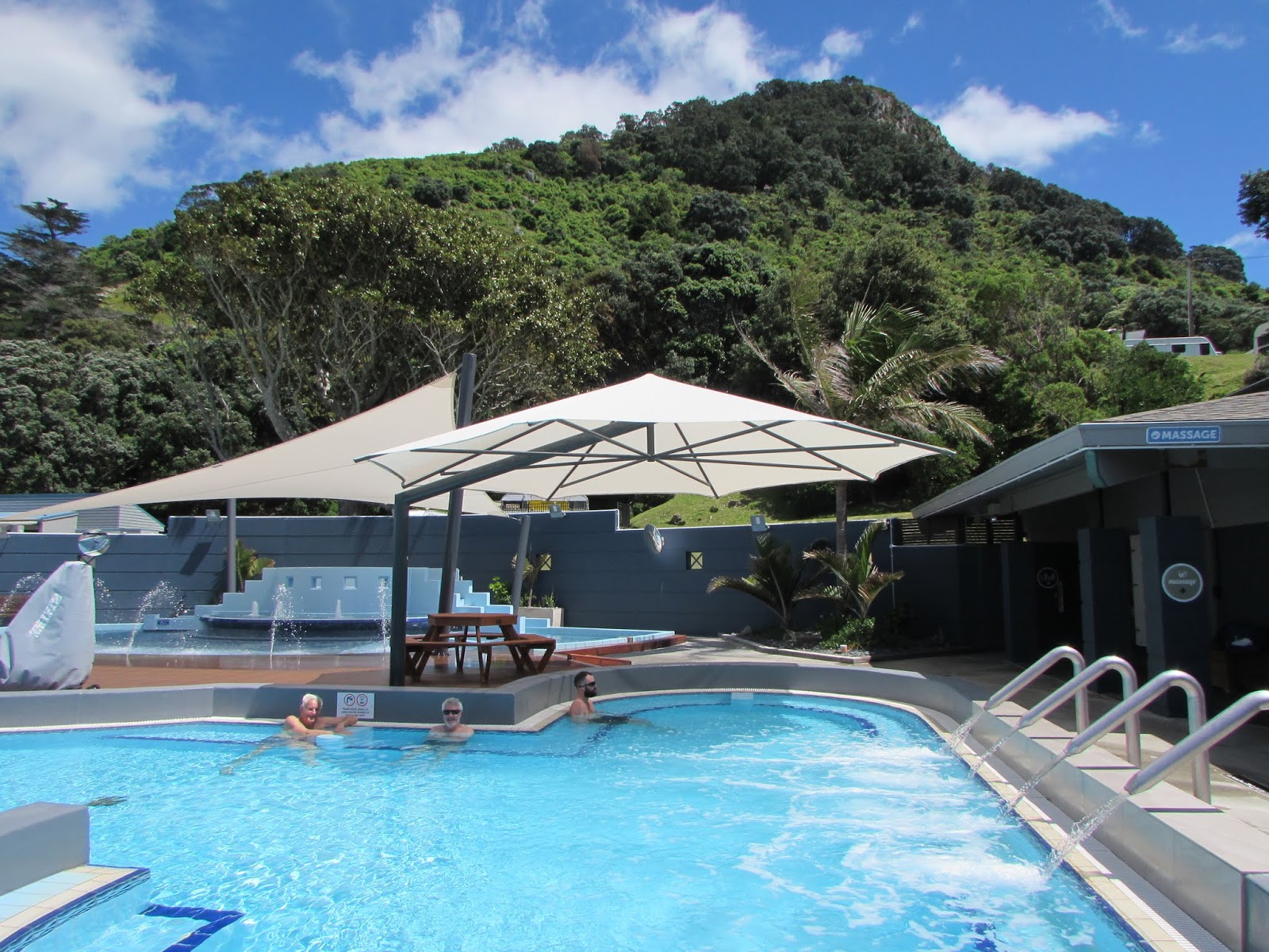
Miranda
Hot Springs was nearby. It was a low
key, traditional hot pool complex with a main pool, a children's pool and an
adult's only sauna pool. A photograph in
the sauna area showed a pool set into the peat bog, circa 1910, taking
advantage of the many natural hot springs along the coast. Later the swamps were drained and the present
pool was built in 1959. A nice spot to
while away the late afternoon.
Our
next freedom camping spot was at Thames, a small town tucked under the
mountains at the foot of the Coromandel Peninsula. While we were in the area we rode the new
cycle trail around the bottom of the Firth of Thames, from Miranda to
Thames. We left from the Shorebird
Centre, riding mostly on a stopbank between the mangrove-fringed estuary and
flat acres of farmland. The trail joined
the road at the settlements of Waitakaruru, Pipiroa and Kopu, where there were
bridges over rivers, before looping back into the empty landscape. The skies were huge and the distant mountains
smudges of blue on the horizon.
The
Kopu Bridge is a landmark. Built in 2011
it replaced the old, one-lane swingbridge that still stands beside it. The old bridge is a category 1 historic
place, being the only remaining bridge of its type in the country. The new bridge has carved pou and other
motifs that celebrate the local iwi's guardianship of the river. From the bridge we turned and cycled beside
the Waihou River into the Thames township.
Now a
quiet settlement, Thames was built during a gold rush in the 1860s and 70s. At
that time it was the second largest town in New Zealand, though it is hard to
believe that when wandering around the streets today! After the gold rush petered out, Thames
remained the same size and is the largest town on the Coromandel
Peninsula. We enjoyed walking around
admiring the old buildings, legacies of the boom times. We loved the cafes and interesting little
shops in the northern section of the township, which also has pretty old
churches and several museums, including the School of Mines and Mineralogical
Museum.
Gold
mining and logging of kauri forests were the reasons Europeans came to the
Coromandel. Once these resources had
been exploited the mountainous area once again became peaceful and sparsely
populated. In the twentieth century many
inhabitants of the peninsula were artists, crafts-people and those seeking
alternative lifestyles. The Coromandel
still retains a quirky, hippy-ish vibe and has a laid-back atmosphere. During the height of summer visitors seek out
its beautiful, remote beaches and throng in the campgrounds and cafes along the
east coast settlements of Whitianga, Tainui and Whangamata. At other times though, the Coromandel
Peninsula can seem almost deserted, and the visitor can have bits of this paradise
all to themselves.
 |
| Our bus, Tangaroa, and our car with bikes on the Coromandel |
We
took the road north from Thames. It was
narrow and windy, each corner revealing another pōhutukawa-framed beach. The Coromandel Ranges reared skywards to our
right, while on the left the Firth of Thames stretched across to Miranda and
Kaiaua. An hour's drive brought us past
the rugged harbours of Manaia and Te Kouma to the tiny township of Coromandel
where we parked in the NZMCA park, a couple of minutes walk from the town
centre.
The
town, harbour and peninsula were named after HMS Coromandel, a ship that
anchored in the bay in 1820, seeking kauri spars. Coromandel town developed from that time,
making it the oldest settlement on the peninsula. The town, little more than a village really,
has the feel of a place that time forgot.
We spent a pleasant half an hour exploring the craft shops before
heading to Driving Creek Railway and Potteries, a couple of kilometres north of
the town.
 |
| On the train at Driving Creek |
The
first time we visited Driving Creek, its owner, Barry Brickell, was still
alive. Brickell, New Zealand's first
full time potter, bought this block of land in 1961. Needing clay, he constructed a narrow-gauge
railway to quarry it and, over time forged a track up through the mountainous
bush, building bridges and tunnels as he went.
In 1990 the Driving Creek Railway opened to the public and has become a
tourist attraction. On our previous
visit Brickell drove the train and recounted how he and his helpers had built
the railway, studding the earth banks with bottles from the wine and beer they
drank after hard day's work. At the top
of the ride Brickell explained how the once extensive kauri forests had been
decimated by logging, leaving a denuded landscape. Driving Creek was named by the loggers for
the creek they dammed to flush the logs downstream. A passionate conservationist, Brickell
planted hundreds of native trees on his property to help regenerate the forests
of old. Sadly Barry Brickell passed away
in 2016; he is buried beside the railway in the bush that he loved.
Since
our earlier visit, Driving Creek Railway has altered a bit. The shop, station and pottery area are little
changed—with quirky clay and pottery figures around the kilns. But now two trains at a time make the three
kilometre ascent, driven by drivers employed by the Driving Creek Trust. Along the route we still enjoyed spotting
whimsical figures beside the track, and still had great views of the coastline
from ridge-top platforms as the train wound around two spirals, through three
tunnels, over viaducts and into five reversing points. What was new was the final section of track
to the Eyefull Tower—a large viewing platform.
From here we could see even more stunning views across the Hauraki Gulf.
There
is a route north from Coromandel, sixty kilometres of narrow, and partly
unsealed road continues through tiny Colville to Port Jackson. At Fletcher Bay there is the start of a
coastal walkway that finishes at Stony Bay, a ten kilometre walk. Saving exploration of this part of the
Coromandel for another time, we took a quick side trip onto the unsealed 309
road (one of the two wild roads that cross the peninsula between SH 25 to the
north and 25a in the south). Coromandel
quirkiness continued here at Waiau Waterworks, a theme park, Coromandel-style,
where everything was driven by water and made from recycled bits and
pieces. Further on we admired nature in
the form of Waiau Waterfall and a grove of kauri that survived logging. Among the trees was an unusual double kauri,
formed by two trees growing close together.
 |
| At Waiau Waterworks |
Leaving
Coromandel Town, Tangaroa struggled
over the steep mountain range to the eastern side of the Coromandel
Peninsula. We stopped at Whitianga's
NZMCA park and over the next few days used the car to explore some
beaches. No wonder Coromandel is
well-known for its beaches—these were some of the most amazing I have visited!
 |
| New Chums Beach |
First
we drove to Whangapoua, a pretty beach in itself and starting point for the
walk to New Chums Beach. We reached this
iconic bay after walking along the sandy beach and scrambling over a rocky
section before cutting across a headland full of nīkau and big, old pōhutukawa. The suddenly we were there. The sandy beach curved away, backed by bush
and the sea glistened in the sun. New
Chums has no road access, no camping, and was named by Britain's Observer newspaper
as one of the world's top ten beaches.
It was definitely worth the half hour walk and we were thankful that a
recent public campaign had prevented development of the land, keeping the
pristine beach to be enjoyed by everyone.
 |
| At Mercury Bay on the Coromandel |
We
enjoyed some more stunningly beautiful and almost deserted beaches at Opito Bay
and nearby Otama Beach before heading off to see some more well-known
spots. Cathedral Cove and Hot Water
Beach are Coromandel's best known and widely visited places. We walked to Cathedral Cove from Hahei Beach,
although in high summer there is a shuttle bus to a car park part way along the
route. The beach is named for the arch
that separates two beautiful sandy beaches, presumably because of its
resemblance to arches inside European Cathedrals. This was a lovely safe swimming spot and we
were glad we had arrived early in the morning as the beach was not crowded.
 |
| Cathedral Cove |
At
Hot Water Beach the time you visit is down to the tide. The water that oozes from the sand is hottest
at low tide, so that is when everyone makes their way to the part of the beach
where hot springs rise to the surface.
The well-prepared had brought shovels and spades, the rest of us build
little pools with our hands. Before long
we were part of a small community, sitting in our private hot pools, shoring up
the walls and occasionally getting hotter than we planned! Hot Water Beach is not a secluded place—it is
all about cooperation and sociability.
It may be a tourist trap but it is also fun.
The
Māori name for the stretch of coastline from the bottom of the Coromandel
Peninsula to the East Cape is Te Moana-a-Toi.
Toi was a Māori ancestral explorer who arrived from Polynesia in the
13th century. Tradition tells of other
canoes that subsequently arrived and the voyagers settled along the fertile
coast. Captain James Cook named the area
the Bay of Plenty after receiving abundant supplies from local Māori when the Endeavour sailed along the coast in
1769.
 |
| Waihi Beach |
We
like to park Tangaroa at quiet
beach-side spots and found lots of those along the coast after we left the
Coromandel behind. We started our
leisurely tiki-tour at Waihi Beach at the north end of the Bay of Plenty, which
has nine kilometres of golden sand ideal for swimming and surfing. We walked north around the headland from here
to pōhutukawa-fringed Orokawa Bay. We
also freedom camped at the south end of the peninsula at Anzac Bay. There are two pa sites here to explore, and
views south along Matakana Island.
 |
| One of Katikati's murals |
Katikati,
known as 'Mural Town' was our next stop.
These murals (there are more than 50 of them) began to be painted in the
1990s and the programme is on-going. A
walk around town was a history lesson, as the murals tell stories of the life
and times of Katikati's people. There
are also quirky sculptures, carvings and a Haiku Pathway where poems are
inscribed on boulders. There are hot
pools nearby at Athenree, where we went for a soak one day. (We never can resist a hot pool!)
Another
great beachfront stop was at Omokoroa, on a peninsula behind Matakana
Island. There was a caravan and
motor-home park here, also a holiday park with thermal pools. Freedom camping is permitted in the large car
park area beside the store at the wharf and this is where we parked Tangaroa. A headland walk took us past the site of the
old homestead and amongst heritage trees planted by the first European
settlers.
 |
| A mural at Tauranga |
Tauranga is the Bay of Plenty's only
city. We like the way its downtown area
is compact and easy to get around. We
freedom camped at Sulphur Point near the marina so could easily walk to the
city centre. We picked up an art walk
brochure from the visitors centre and strolled along the waterfront and nearby
streets checking out the pou, sculptures and particularly the huge murals
created by local artist Owen Dippie.
Tauranga's art gallery is well worth a look too. We were lucky enough to catch the Wildlife
Photographer of the Year exhibition, on tour from the UK. Tauranga was the only New Zealand venue for
the prestigious exhibition.
 |
| On a cycle trail at Tauranga |
European
settlers arrived in Tauranga in the 1830s, among the first were
missionaries. The Elms Mission was
established in 1835 with the Georgian style house being built in 1847. The house and grounds are open to the public. We were amazed to see a photograph of the
residents of one hundred years ago sitting in their garden, with nothing but
beach and estuary between them and Mount Maunganui. It is all a whole lot busier and more
industrial now.
 |
| A view from Mt Maunganui |
A
climb to the top of Mount Maunganui (Mauao), known locally as 'the mount', is a
must-do. There are tracks around and up
to the summit of this 232 metre-high dormant volcano. The loop walk takes about one and a half
hours and we were rewarded by 360 degree views from the summit. After our exertions we felt that we had
deserved a soak in the hot pools nestled at the base of Mauao. These pools are unusual in that they are
thermally-heated, salt water pools.
Being great lovers of hot pools we have an extensive knowledge and these
are some of the best we have visited.
 |
| Mt Maunganui's Hot Pools |
Volcanoes
and thermal activity are never far away in the Bay of Plenty. While the cone of Mount Maunganui is a
landmark, out to sea there are three volcanic islands—Mayor, Whale and White
Island. White Island is New Zealand's
most active volcano, last erupting in 2013.
The plume of steam emanating from the island is a constant reminder that
we live in a potentially volatile environment!
One of the benefits of the area's volcanic past is that the soil
contains volcanic ash and is free-draining and moist. This has led to the growing of fruit, particularly
kiwi fruit. More than 70% of New
Zealand's kiwifruit is grown in the Bay of Plenty with the town of Te Puke
celebrated as the 'Kiwifruit capital of the World'.
After
leaving Sulphur Point we drove to Pukehina Beach, which is situated along a
sandbar between Papamoa Beach and Matata.
Freedom camping is allowed at each end.
Dotterel Point, at the northern tip, has an estuary on the landward side
of the spit. A walk along the beach will
reward birdwatchers with sightings of this threatened species as the reserve
contains more than 18 breeding pairs.
 |
| Pukahina Beach |
Eventually
we made our way to Whakatane, in the south of the Bay of Plenty. This town is very different in feel from
sophisticated Tauranga—here Māori history is paramount. A sculpture representing Wairaka, daughter of
the captain of the Mātaatua canoe, stands at the entrance to the harbour. Legend tells that when the voyagers arrived
at Whakatane and the men had gone ashore, the tide turned and threatened to
carry the canoe back out to sea. The
situation was saved by Wairaka who cried out, "Kia Whakatane au i
ahau!"—let me act like a man. Over-riding
custom, she and the other women paddled back.
Thus Whakatane got its name.
There is a memorial to the Mātaatua
canoe along the waterfront, also a ceremonial waka replica.
The
Mātaatua Wharenui is known as New Zealand's most travelled Māori meeting house. It was completed in 1875, then a few years
later the government sent it overseas to represent New Zealand—first in London,
then in Sydney and Melbourne. After
travelling the world for 130 years, the wharenui was returned, and rebuilt in
Whakatane in 2011. The adjacent visitors
centre tells the story, while the meeting house is open for tours daily.
Just
south of Whakatane we freedom camped at Ohope Beach, voted New Zealand's 'most
loved beach'. There are shops and cafes
nearby and, for those who prefer a harbour view, there is another freedom spot
at the end of harbour road beside the golf course.
 |
| Whakatane |
Information about places mentioned in this post - correct at time of writing
Walks
- ·
Mt Maunganui (Mauao)
Base Track walk
www.freewalks.nz/tauranga-tramping/mt-maunganui-base-track/track
3.5 km, 40 min, easy
Summit Track
www.freewalks.nz/mt-maunganui/mt-maunganui-summit-walk/track
easy (but steep) walking
track to 232 metre-high summit, 30-45 min one way
Places to visit
- ·
Pūkorokoro Miranda
Shorebird Centre
283, East Coast Rd,
Pokeno
www.miranda-shorebird.org.nz
Hours: 9.00 am-5.00 pm
- ·
Miranda Hot Springs
Front Miranda Rd, Miranda
www.mirandahotsprings.co.nz
Hours: 9.00 am-9.00 pm
Entry price: adult $14,
child $7, non-swimmer $9
- ·
Driving Creek Railway and
Potteries
380, Driving Creek Rd,
Coromandel
www.drivingcreekrailway.co.nz
Hours: 8.00 am-7.00 pm,
see website for timetable
Entry price: adult $35,
senior and student $32, child $13
- ·
The Waiau Waterworks
471, The 309 Rd, Waiau
https://thewaterworks.co.nz
Hours: 10.00 am-6.00 pm
summer, 10.00 am-4.00 pm winter
Entry price: adult $25,
senior and child $20
- ·
Athenree Hot Springs
1, Athenree Rd, Athenree
http://athenreehotsprings.co.nz
Hours: 10.00 am-7.00 pm
Entry price: adult $8,
senior $7, child $5.50
- ·
The Elms Te Papa Tauranga
15, Mission St, Tauranga
www.theelms.org.nz
Entry price: adult (NZ
resident) $10, (Tauranga resident) $7.50, (International Visitor) $15; child
(NZ resident) $5, (Tauranga resident) $3.50, (International Visitor) $7.50
- ·
Mount Hot Pools
9, Adams Ave, Mt
Maunganui, Tauranga
https://mounthotpools.co.nz
Hours: 6.00 am-10.00 pm
Monday-Saturday, Sunday and public holidays 8.00 am-10.00 pm
Entry price: adult $14,
senior and child $9,
- ·
Mātaatua meeting House
105, Muriwai Dr,
Whakatane
https://www.mataatua.com/
Visitor Centre hours:
9.00 am-4.00 pm, entry free. Tours of
the wharenui, etc, can booked here


No comments:
Post a Comment