
The Hawke's Bay is famously hot and sunny and it lived
up to its reputation on our visit.
Cycling amongst the vines, tramping to Cape Kidnappers and Te Mata Peak,
admiring the art deco buildings of Napier—there was always something to see and
do.
Captain
Cook and his crew were the first Europeans to see the Bay, named by Cook after
the First Lord of the Admiralty, Sir Edward Hawke. It was on Cook's expedition of 1769 that Cape
Kidnappers was named too. A Tahitian
servant boy was briefly captured by local Māori but escaped when the crew of
the Endeavour opened fire. Māori mythology describes the Cape as Te
Matau a Māui, Māui's Fishhook, which he used to haul up the North Island from
the ocean bed.
The
Hawke's Bay's dry, temperate, climate led to the region becoming renowned for
its orchards and vineyards. Early
missionaries first planted grapes in the region, which now boasts around 75
wineries, which make up 80% of New Zealand's merlot, cabernet sauvignon and
syrah grapes plantings. (We were
soon to get to know some of these vineyards.)
Long a site of Māori villages and fortifications, Napier began to be
developed after 1851. Sister town
Hastings was laid out two decades later, and at the time of the 1931 earthquake
both towns had similar populations. The
earthquake of February 3rd decimated both townships, levelling buildings and
causing large areas of land, much of it coastal lagoon, to rise. After the tragedy both towns, but particularly
Napier, were rebuilt in the fashionable style of the era, art deco.
 |
| Art Deco Napier |


There
are daily guided walks and vintage car or bus tours to discover the distinctive
buildings in Napier's art deco historic precinct but we just walked around
admiring the architecture. The area is
roughly three blocks square and is interspersed by street art, sculpture and
fascinating shops and cafes. It is an
easy place to spend a few hours. There
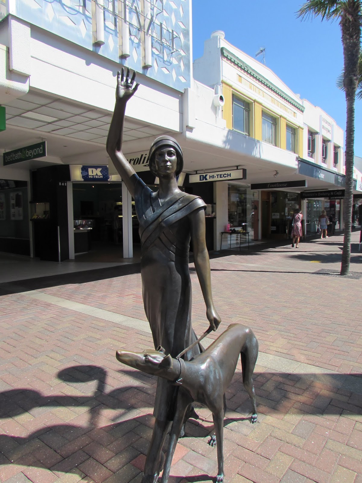
is also plenty to see along Napier's waterfront, Marine Parade—we admired the
sound shell, the sunken garden and the bronze statue of Pania of the Reef. One of Napier's most photographed
attractions, the statue commemorates the Māori legend of Pania who was one of
the sea people but married a mortal, Karitoki.
Punished for her behaviour, she was transformed into a reef. The legend was perpetuated when the statue
was presented to the city in 1954. Pania's
face was modelled on a local girl, May Robin.
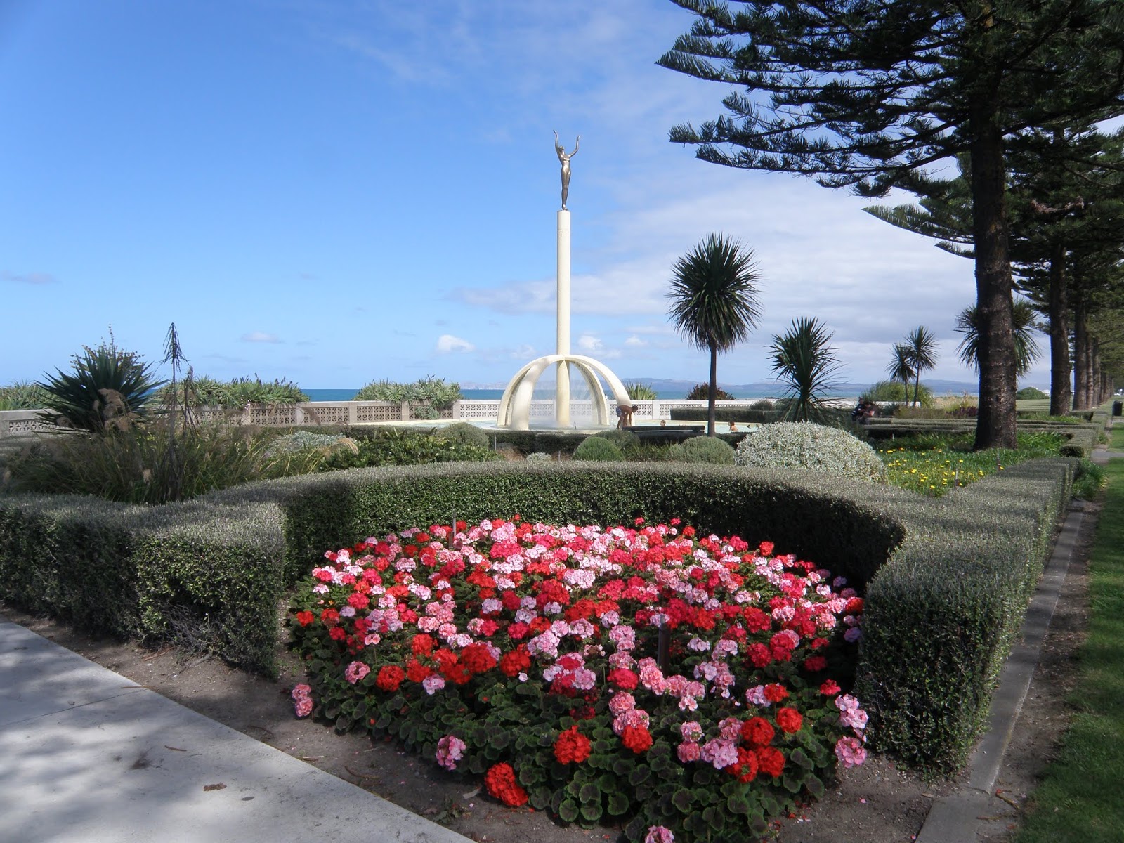
Further along the Parade, the art deco-influenced Spirit of Napier
features the form of a young woman reaching upwards, representing Napier rising
from the ashes of the earthquake. In a
similar vein, the bronze statue a Wave in Time on Emerson Street features
Sheila Williams, who led the New Napier Carnival in 1933.
 |
| Pania |
 |
| Napier's waterfront |
Napier
is great for cycling around. Tangaroa was parked at the NZMCA Park close
to town and one evening we decided to get fish and chips for tea. We hopped on our bikes and headed up the
cycle track that runs parallel to Marine Parade, turning into town by the sound
shell. We thought there would be a
chippy somewhere nearby but couldn't seem to sniff one out. We looked around for someone to ask and
spotted a couple around our age walking by.
I asked them if they knew of a good fish and chip shop nearby but they
turned out not to be locals. Then the
woman turned to me and said, "I was just saying to my husband, look at
that old couple on their bikes. If they
can do it, so can we." Old
couple! Us? I haven't even got close to retirement age
yet!
After some advice from locals and
one or two wrong turns we eventually found a good fish and chip shop a few
streets away. We were taking our food to
eat at one of the seating areas by the beach when I spotted our 'new friends'
advancing. They had been looking for a
McDonalds but seemed to be dogging our footsteps. Luckily we were able to eat our fish supper
without being insulted further.
There
are over 200 kilometres of cycle trails in and around Napier and we rode quite
a few of them. One of the first rides we did was the 'water ride' which takes
in the cafes of Ahuriri's waterfront and the pretty seaside settlement of
Westshore, before looping back through the wetlands of Ahuriri. It is amazing to think that prior to 1931,
when the land was uplifted by earthquake, the wetlands were part of a lagoon
where the locals fished and sailed.
 |
| Cycling the Landscapes Ride |
Cycling
south another day we headed towards Cape Kidnappers on the 'landscapes
ride'. This passed the mouths of the
Tutaekuri, Clive and Tukituki Rivers and associated wetlands, before
terminating at Clifton at the base of Cape Kidnappers. Highlights of this ride were morning coffee
under the vines in Clive and, later, a wine tasting and a long afternoon at
Clearview Estate. The 'wineries ride'
from Fernhill was more of a problem. Its
full circuit is 47 kilometres but we found a wine tasting at Unison Vineyard,
followed by a cycle to Ash Ridge, where we had lunch and shared another bottle,
was as much as we could handle and we wobbled home.
 |
| On the Puketapu Loop |
Probably
the most scenic ride was the Puketapu Loop, which ran alongside the Tutaekuri River
past orchards, vineyards and through shady woodland. At the Taradale end of the loop we came to Ōtātara
Pā Historic Reserve. Comprising of an
upper pā, Hikurangi, and a lower palisaded one, Ōtātara, this site is known as
one of the most outstanding complexes in New Zealand. It took an hour to walk around the pā, where
there are the sites of dwellings, food storage pits and gardens. The Ōtātara site has palisades to convey a
sense of how it would have been fortified.
The views were breathtaking—we could see across to Napier and Cape
Kidnappers. Agricultural land spread
below us was once part of the extensive lagoon that stretched to Ahuriri.
 |
| Pou at Otatara Pa |
Interspersed
with cycling we took in some of the area's wonderful walks. Our first was from Clifton to Cape
Kidnappers. The Cape is famous for its
gannets—it has the largest nesting area in the world. The gannets return each year to nest at the
Cape, pairing for life and rearing one chick each season. There are tours, along the beach by tractor
and overland by coach, but we took the walking option along the beach. This trek took around six hours (return) and
had to be coordinated with the tides—it is only walkable around at low tide.
 |
| Walking to Cape Kidnappers |

We passed
beneath towering cliffs, which vary in age from 300,000 to 4.5 million
years. The bands of strata included
shellfish fossils, conglomerates of pebbles and windblown ash and pumice. Deep canyon-like gullies punctuated the cliff
face at intervals. Around two thirds of
the way into the walk the beach scenery changed—we came to rocky islets and an
area known as black reefs, where there were colonies of gannets. They seemed unconcerned by us and it was easy
to get very close to them.
After
two hours walking we came to a picnic area and then it was a steep half an hour's
walk up to the plateau. But what a
sight! There were colonies of gannets on
the plateau and surrounding flat areas of cliff. Oblivious to observers they took off and
landed, preened and squabbled, fed their young and courted their mates. The walk would have been good without the
gannets—but they made the experience unique.
 |
| Gannets galore |

Another
iconic walk in the region was Te Mata Peak, five minutes drive from Havelock
North. You can drive or walk to the
summit but we took one of several loop walks (the Giant Circuit) from the
bottom car park up to the trig on the 399 metre-high summit. Our track passed through soaring redwoods, before
zigzagging its way up a steep ridge to the top.
The 360 degree views were wonderful—we could even see, hazily, Mt Ruapehu
150kilometres away.
 |
| Fantastic views on the Te Mata Peak walk |

Back
aboard Tangaroa, we hitched the car
behind us and headed south.
Information about places mentioned in this post - correct at time of writing
Walks
- ·
Ōtātara Pā Historic
Reserve Walk
Springfield Rd, Taradale
www.doc.govt.nz/parks-and-recreation/places-to-go/hawkes-bay/places/napier-area/otatara-pa-historic-reserve
1.6 km, 45 min one way,
easiest: short walk
- ·
Te Mata Peak
http://tematapark.co.nz/maps-and-tracks
Giant Circuit: 5.4 km, 2-2.5 hr, intermediate
Access: Te Mata Peak Rd,
Havelock North
- ·
Cape Kidnappers Walking
Track
www.doc.govt.nz/parks-and-recreation/places-to-go/hawkes-bay/places/cape-kidnappers-gannet-reserve/cape-kidnappers-walking-track
19 km return, 5 hrs, easy:
walking track
Access: End of Clifton
Rd, Clifton
Cycle Trails
- ·
Napier Cycle Trails
·
www.nzcycletrail.com/trails/hawkes-bay-trails
Water Ride: 33 km, grade: easiest
Landscapes Ride: 56 km, grade: easiest and
intermediate
Wineries Ride: 48 km, grade: easiest and easy
Puketapu Loop: 18 km, grade: easiest and easy


No comments:
Post a Comment